AI-Powered, Decision-Ready Insights
Seabed to Space
Satellite, Drone, and IoT Intelligence
+
Offshore Geotechnical & Structural Engineering
A Tale of Innovation, Purpose, and Impact
Orcintech is built upon two pillars:
- AI & Remote Sensing Intelligence (TerraXai®)
- Offshore Geotechnical & Structural Engineering
At Orcintech, we bring together Earth intelligence, AI, advanced sensing technologies, and conventional engineering process to help communities make smarter, safer, and more sustainable decisions on infrastructure, natural resources, and environment.
Years Experience
Trusted Partners
Publications
Turning Earth and Geohazards Observations Into Operational Intelligence

Knowledge
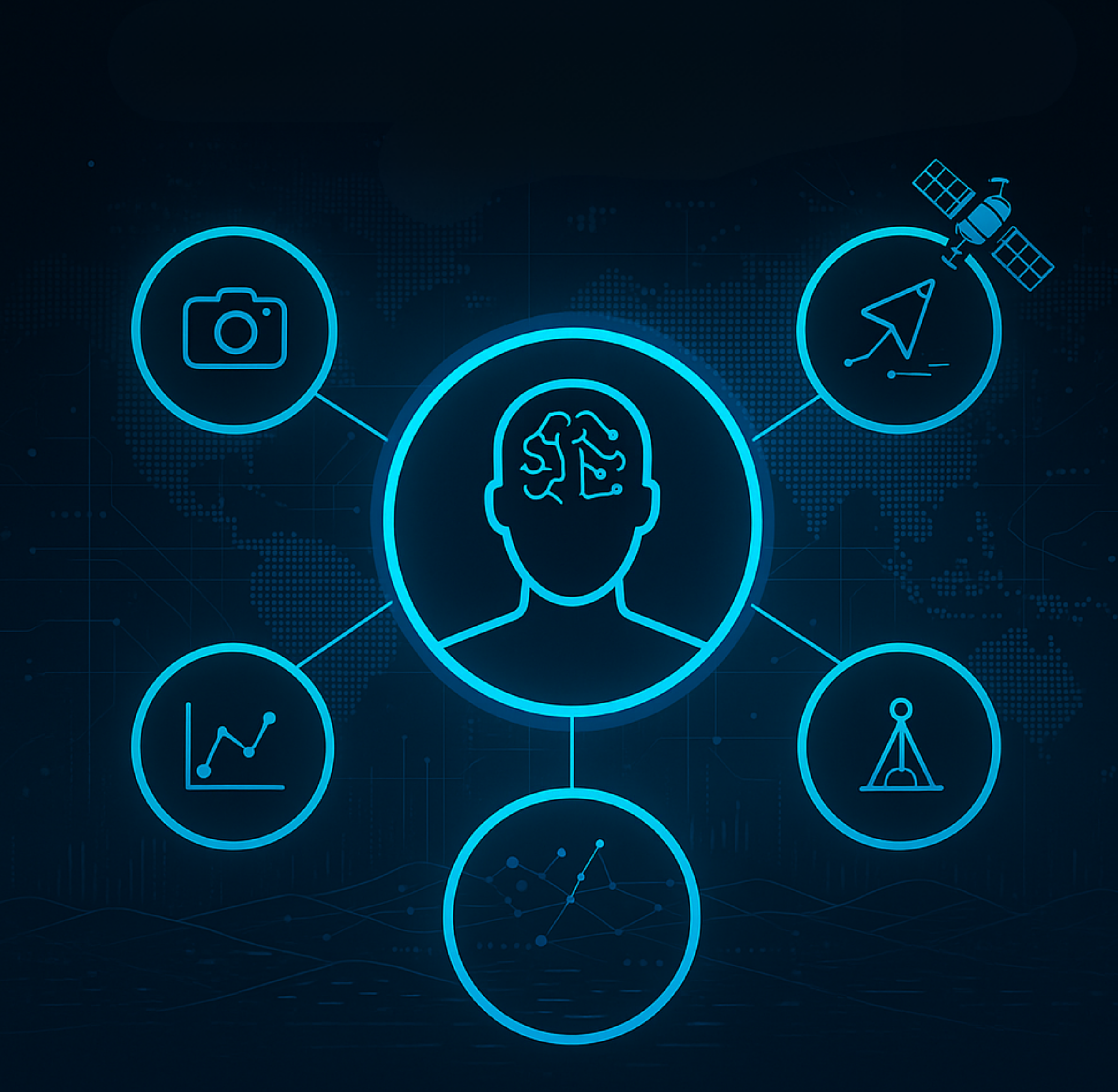
A central hub of Earth data insight, scientific expertise, and practical experience across satellites, sensors, AI systems, and offshore geotechnical and structural engineering.

Conversations
Open channels for questions, insight, and direct guidance across all parts of our operational AI platform.

Product
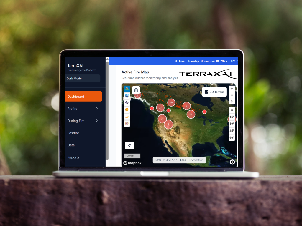
A next-generation system with multi-sensor input, satellite data, advanced AI algorithms, and intelligent agents for real infrastructure, natural resources, and environmental awareness.

Support
Full assistance through expert guidance, clear answers, and reliable help across all platform features.
Our Core Services
At Orcintech, we deliver advanced Earth-intelligence solutions, along with offshore geotechnical and structural engineering services to help you monitor, understand, build, and protect our changing environment.
Climate & Environment
A next-generation climate and environment intelligence system that fuses satellite observations, geospatial data streams, environmental sensing, and AI-powered analytics to enable continuous monitoring and informed assessment of climate impacts and environmental change.
Energy & Decarbonization
An advanced energy intelligence solution leveraging satellite data and AI analytics to track emissions, improve operational efficiency, and accelerate the transition toward low-carbon and sustainable energy systems.
Smart Cities & Urban Planning
An intelligent smart city and urban analytics solution that integrates satellite imagery, urban data layers, and AI-driven insights to support sustainable planning, infrastructure optimization, and data-informed urban decision-making.
Ports & Maritime
A smart maritime intelligence ecosystem that connects sea, shore, and infrastructure through satellite data and artificial intelligence, enabling safer navigation, optimized port operations, and resilient coastal management.
Power & Utilities
An advanced utility analytics capability that combines infrastructure data, spatial intelligence, and predictive modelling to support reliable power delivery, asset lifecycle management, and system resilience.
Real Estate & Housing
A data-driven real estate and housing intelligence solution that supports site evaluation, asset monitoring, and development planning through integrated spatial analysis and digital assessment tools.
Precision Agriculture
A modern precision agriculture framework that combines geospatial intelligence, environmental indicators, and analytical models to improve crop performance, land management, and input efficiency.
Mining & Minerals
A data-driven mining intelligence solution that supports mineral exploration, site assessment, and operational monitoring through integrated spatial analysis and subsurface data interpretation.
Infrastructure & Transportation
An advanced analytics framework for transportation and infrastructure systems, enabling condition assessment, network analysis, and informed decision-making across roads, rail, and civil assets.
Smart Wildfire Management
A next-generation wildfire intelligence system that combines satellite data, IoT sensor networks, camera observations, and autonomous AI agents for fast, reliable wildfire detection and monitoring.
Wildlife Monitoring
An advanced wildlife monitoring solution powered by satellite imagery, IoT sensors, field cameras, and intelligent AI agents, delivering accurate insights into wildlife movement, habitat changes, and ecosystem health.
Forestry & Vegetation
A modern forestry, vegetation and land-health monitoring solution using satellite imagery, ground sensors, and AI models to deliver precise, real-time insights for landscape management and environmental stewardship.
Water & Hydrology
An advanced data-driven water and hydrology intelligence solution that supports watershed analysis, flood and drought assessment, and water resource management through integrated spatial data and environmental analytics.
Waste Management
An smart digital intelligence approach for waste and resource management that enhances operational visibility, supports compliance, and improves planning across collection, treatment, and disposal activities.
Tourism & Cultural Heritage
A data-driven tourism and cultural heritage intelligence solution that supports site monitoring, visitor analysis, and heritage preservation through integrated spatial data and contextual analytics.
TerraXai
Next-Generation Earth Intelligence with Multi-Sensor Data, AI Systems, and Orchestrated Intelligent Agents
Gain instant access to critical infrastructure and environmental insights through TerraXai, our advanced Geospatial platform powered by satellite data, dynamic analytics, and intelligent Earth agents.
