

TerraXInfra
An Intelligence Platform with Multi-Sensor Data and AI Systems for Infrastructure & Transportation Management

Infrastructure & Transportation Intelligence
TerraXInfra empowers infrastructure and transportation leaders to build smarter, safer, and more resilient systems. The platform delivers precise insights on buildings, bridges, roads, and land deformation, while tracking urban growth in real time. TerraXInfra as a GIS-driven spatial analysis platform unlocks a deeper understanding of assets, land use, and transportation networks, fueling better planning, construction, and maintenance. Through TerraXInfr‘s immersive Digital Twin models, clients can simulate scenarios, inspect assets virtually, and monitor structural stability to optimize performance and safety. By combining these technologies, we help cities and industries reduce risks, cut costs, and drive sustainable growth
Featured Applications
Deformation Monitoring
TeraXInfra powered by TerraXai enables accurate infrastructure deformation monitoring by analyzing high-resolution satellite imagery and time-series geospatial data to detect subtle ground movement and structural displacement. The intelligent platform supports continuous monitoring of roads, bridges, dams, pipelines, and buildings, identifying early signs of subsidence, settlement, or structural stress. These insights enable proactive maintenance, risk mitigation, and asset lifecycle optimization, helping infrastructure owners improve safety, reduce failure risks, and make informed, data-driven management decisions. Some of the key feature include:
- SAR data for continuous monitoring of ground and structural deformation.
- InSAR techniques to quantify millimeter-scale displacement.
- Continuous tracking of deformation to detect movements or stress accumulation.
- Machine learning models to identify early warning indicators and structural risks.
- Fusion of satellite data with GNSS, inclinometers, and IoT sensors
- Cloud-Based Dashboard: Interactive GIS platform for visualization, automated alerts, and long-term stability reporting


Infrastructure Inspection & Structural Health Monitoring
TerraXInfra delivers an integrated satellite and UAV-based monitoring framework for assessing bridge stability, deformation, and structural integrity. By combining InSAR satellite data, high-resolution UAV imagery, and AI analytics, the system enables millimeter-scale precision in detecting displacement, cracks, and material degradation, enhancing infrastructure safety and maintenance efficiency. Some of the key features include:
- Satellite-based deformation monitoring
- UAV inspection and 3D reconstruction
- AI-driven anomaly detection
- Integration with IoT sensors
- Cloud-based dashboard
Geospatial Infrastructure Monitoring
TerraXInfra delivers AI-powered geospatial infrastructure monitoring combined with Digital Twin technology that enables continuous, intelligent assessment of critical assets by integrating satellite data, spatial analytics, and real-time models. The Digital Twin provides a dynamic virtual representation of infrastructure, allowing AI algorithms to detect changes, predict degradation, and simulate performance under different conditions. This approach supports proactive maintenance, risk forecasting, asset optimization, and scenario-based decision-making for transportation networks, utilities, and urban infrastructure, improving resilience, safety, and lifecycle efficiency.

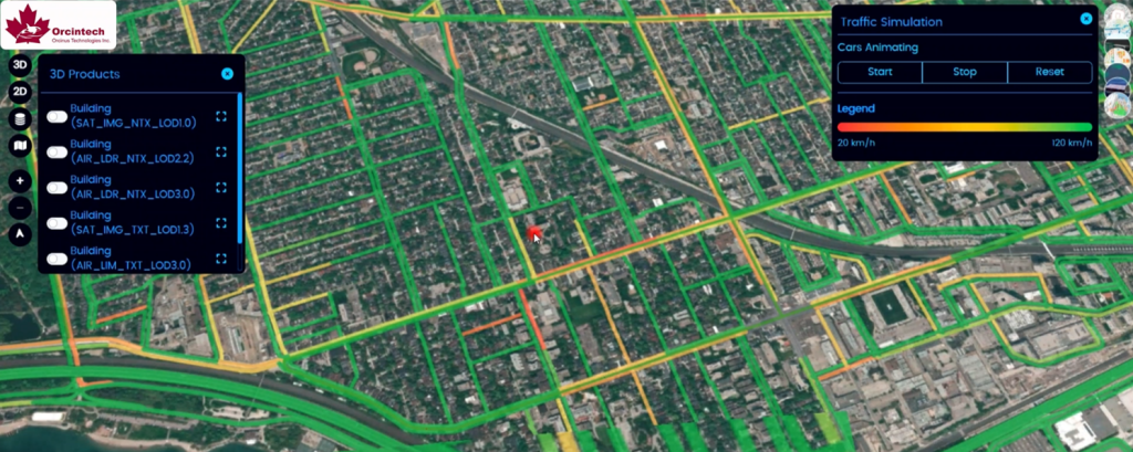
Traffic optimization and transportation monitoring along with CCTV Intelligence
TerraXInfra as an AI-driven traffic intelligence transforms urban mobility by turning roads into living, responsive systems. By fusing geospatial analytics, real-time traffic data, and AI-powered CCTV vision, the platform continuously interprets vehicle movement, congestion behavior, and incident patterns across the transportation network. Intelligent algorithms optimize traffic flow in real time, predict bottlenecks before they form, and enable adaptive signal control to reduce delays and emissions. Integrated video analytics add situational awareness by detecting accidents, abnormal driving behavior, and safety risks as they happen. The result is a smarter, safer, and more efficient transportation ecosystem that improves commuter experience, enhances public safety, and supports data-driven urban mobility planning.


Renewable Energy Site Suitability and Monitoring
Remote Sensing (Satellite + Drone)
- Satellite-based monitoring using multispectral, SAR, thermal, and InSAR data for terrain stability, subsidence, vegetation, and climate impacts.
- Drone inspections with RGB, thermal, LiDAR, and multispectral sensors for panel-level PV defects, wind turbine blade damage, and 3D structural assessment.
- High-resolution 3D terrain models for site planning, expansion, and environmental compliance.
AI Analytics & Predictive Intelligence
- AI-driven solar/wind production forecasting using satellite irradiance, and weather.
- Automatic detection of hotspots, soiling, cracks, erosion, and component degradation.
- Predictive maintenance models estimating remaining useful life (RUL) of turbines, inverters, and transformers.
- Root-cause loss analysis (shading, microclimate, mechanical issues).
Digital Twin
- Real-time 3D digital twin of solar farms, wind farms, and transmission assets.
- Unified integration of satellite and drone data, IoT sensors, and SCADA streams.
- Live dashboards for performance, anomalies, and environmental risks.
- Scenario simulations for optimal panel tilt, wind farm wake effects, weather resilience, and expansion planning.